
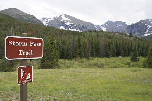
Taking the advice of a friendly hiker we met drinking beer on the trail last month (him, not us), we did a loop hike this Saturday, starting at the Storm Pass trailhead in Rocky Mountain National Park. NO DOGS FOOLS!!!
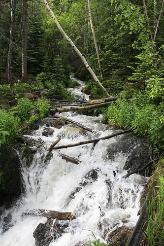
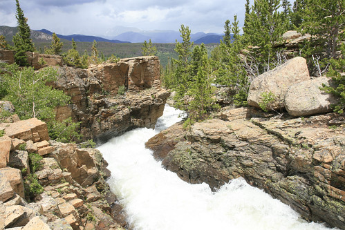
What was initially a short loop intended to keep us out of the high country on a potentially stormy day, became more and more ambitious as the day progressed, until we had been hiking for 10 1/2 hours and covered at least 14 or 15 miles. Before embarking on our journey, we had decided to add a bushwhack up nearby 11,482 foot Half Mountain (at the far left in the above photo) to the loop we had been recommended. We followed the Boulder Brook Trail for the first 2.5 miles on a pleasant climb devoid of tourists, dogs, horses, and other unpleasant animals sometimes encountered in the wild. The solitude of the woods was interupted often by the thundering sound of nearby Boulder Brook, which was absolutely slammin' with snowmelt.
At one point a hummingbird mistook Laura for a giant flower. After buzzing around her bright pink shirt, it couldn't find a place to extract nectar, and moved on disappointed it hadn't found the world's largest flower (photos of the shirt appear later). At the junction with the North Longs Peak Trail, we started our bushwhack southwest through the forest.
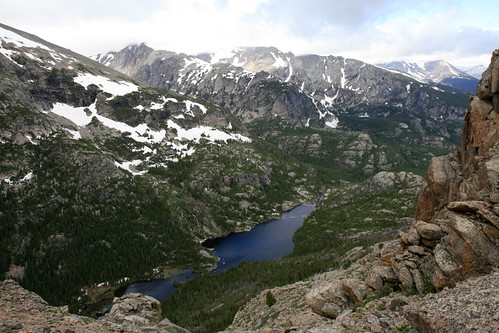
Without the aid of my battery deficient GPS, we ended up at Point 12,158 (700 feet higher than Half Mountain), the first of our extra mileage. After being pummeled by an absolutely ferocious wind on the summit, we made our way north towards Half Mountain. Despite the clouds and wind, there were no thunderstorms or rain. Here is a view looking down at Glacier Gorge and Lake Mills from the saddle between the two peaks.
After a quick snack on Half Mountain, we started the descent down to the North Longs Peak Trail. Despite the awesome marmot habitat, we saw none; only a few pikas were heard (but not seen) on way down. Route finding was rather easy without the GPS, and after a very steep descent, we were back on the trail near Glacier Creek.
Glacier Creek was massively out of control. It was loud, angry, and definitely not a good place to go for a swim. At this point, the initial plan had us returning to the Glacier Gorge trailhead and taking the shuttle bus back to our car (as recommended by the aforementioned beer drinking hiker), but Laura suggested a short side trip to see The Loch, 1.5 miles in the opposite direction. Once there I suggested adding another mile to see Glass Lake and Sky Pond. Why not? We hadn't seen any wildlife (hummingbirds, bumble bees, and butterflies don't count), and for a day that was supposed to be stormy, the weather was still very cooperative.
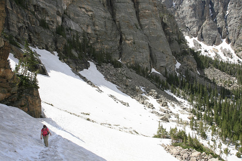
After a mile or so of hiking through the woods, we had to climb a very steep snowbank to gain access to the basin where Glass Lake lies. It got dangerously steep past the point of this photo, but our perseverance would soon be rewarded when we reached the lake.
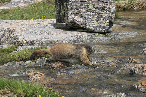
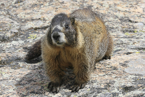
As we were about to leave, I spotted a rather good looking marmot making his way around the lake, no doubt returning home from a visit with his lady friend. He came all the way around the lake to the outlet, where Icy Brook was racing along.
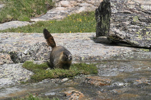
He was going to cross the creek!!
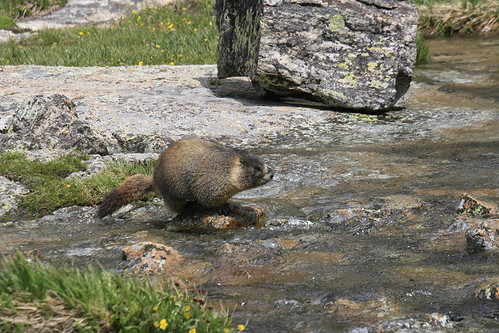
Sizing things up, he hopped from rock to rock with amazing dexterity!!
Marmots may look like lazy fatties, but they can really move when they have to.
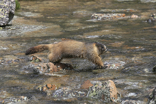
As he made his way across, it became clear that he was heading straight towards us.
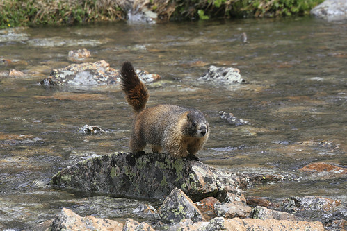
He darted behind a rock, and then all of a sudden, we were standing face to face.
We exchanged knowing glances, and then as quickly as he appeared, he was gone.
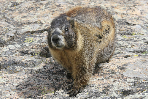
While we only saw one marmot that day, we saw one totally awesome, never to be forgotten, marmot. We decided to abandon the short climb to Sky Pond, as the clouds were threatening and it was getting quite late. On the way down, we helped an older couple that had slid down the steep snowbank. I retrieved one of their hiking poles, but the other was in a precarious spot right above a crevasse. After watching the husband stubbornly retrieve the pole, it started to rain, and we rushed down the trail 4+ miles to the Glacier Gorge trailhead and our shuttle bus ride.
When we noticed that our trailhead was not on the list of bus stops, I started to think, that perhaps, listening to the advice of strangers drinking beer in the woods is not always a wise move. Then when the bus driver told us he didn't stop there, I really started to question my judgement. The driver told us the next closest stop was Bierstadt Lake. How far we asked? A mile away from the Storm Pass Trailhead. I decided 2+ miles of trail hiking beat a mile of road walking, so we were off. The trail paralleling the road was unsurprisingly devoid of people, and we made good time, reaching our car at 6:15pm, 10.5 hours after we had left.
At this point I noticed another parking area a short distance down the road. Less then 2/10's of a mile away was the Bierstadt Lake trailhead, and a couple of lessons learned: it's OK to trust jovial beer drinking hikers, it's not OK to trust incompetent bus drivers.
QUALITY. I didn't know they could raise their tails!
ReplyDelete